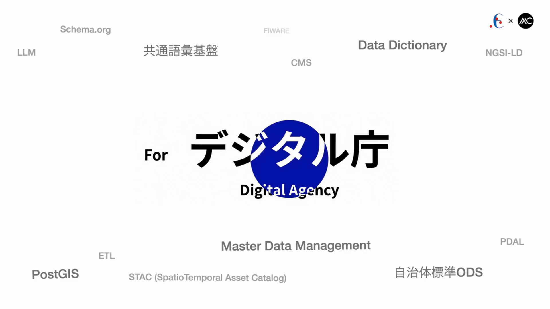
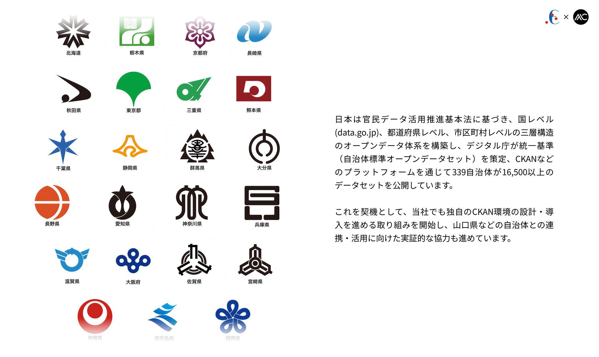
The Basic Act on the Promotion of Public and Private Data Utilization obligates the national government and local public bodies in Japan to advance open data initiatives. The Digital Agency is responsible for coordinating open data policies across the government.
「官民データ活用推進基本法」により、日本の国および地方公共団体にはオープンデータの推進義務が課されています。オープンデータ政策の政府全体での統括・調整はデジタル庁が担っています。
Taking this opportunity, we have begun designing and deploying our own CKAN environment, while also advancing exploratory collaborations with local governments such as Yamaguchi Prefecture for future integration and utilization.
これを契機として、当社でも独自のCKAN環境の設計・導入に着手し、山口県などの自治体との連携・活用に向けた実証的な協力も進めています。
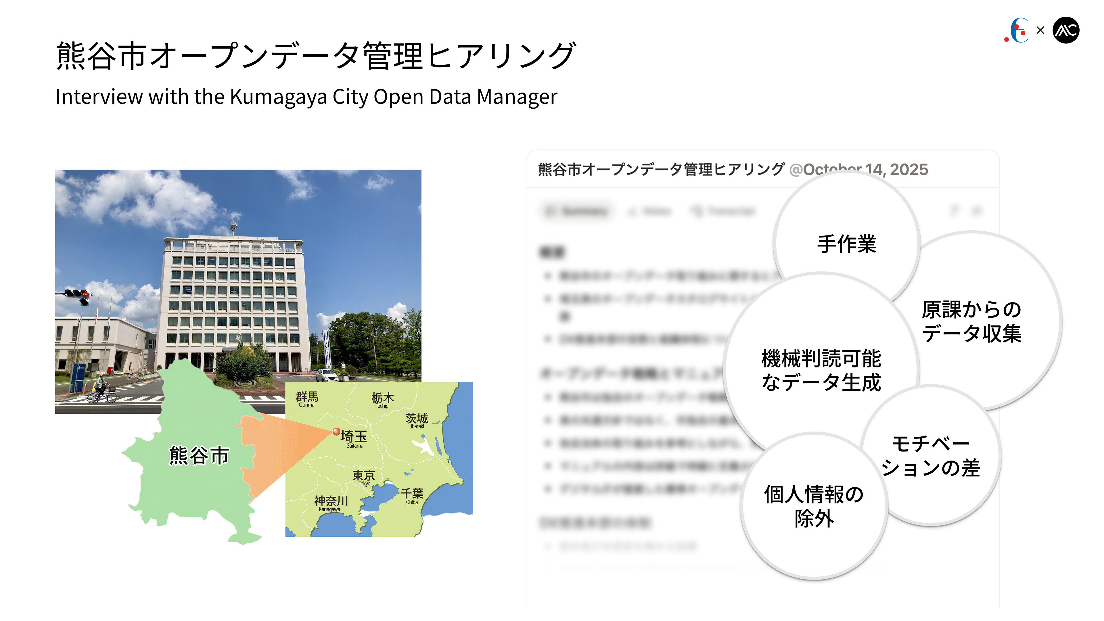
熊谷市は、副市長主導のDX推進本部の支援でFIWARE Orion基盤のオープンデータカタログを構築したが、原課からのデータ収集が最大の課題である。業務担当は効果を実感しづらく動機が弱いほか、デジタル推進課はCSV/Excelの手作業や個人情報の匿名化に負担がある。利活用促進も不十分で、APIは市民には扱いづらく、現状は「公開可能なデータをとりあえず公開する」段階にある。
Kumagaya City built an FIWARE Orion-based open data catalog supported by its DX HQ, but the biggest issue is data collection from departments. Staff lack motivation due to unclear benefits, while the Digital Promotion Division manually processes CSV/Excel and handles anonymization. Utilization is still low, APIs are hard for citizens to use, and the initiative remains at an early “publish whatever can be published” stage.
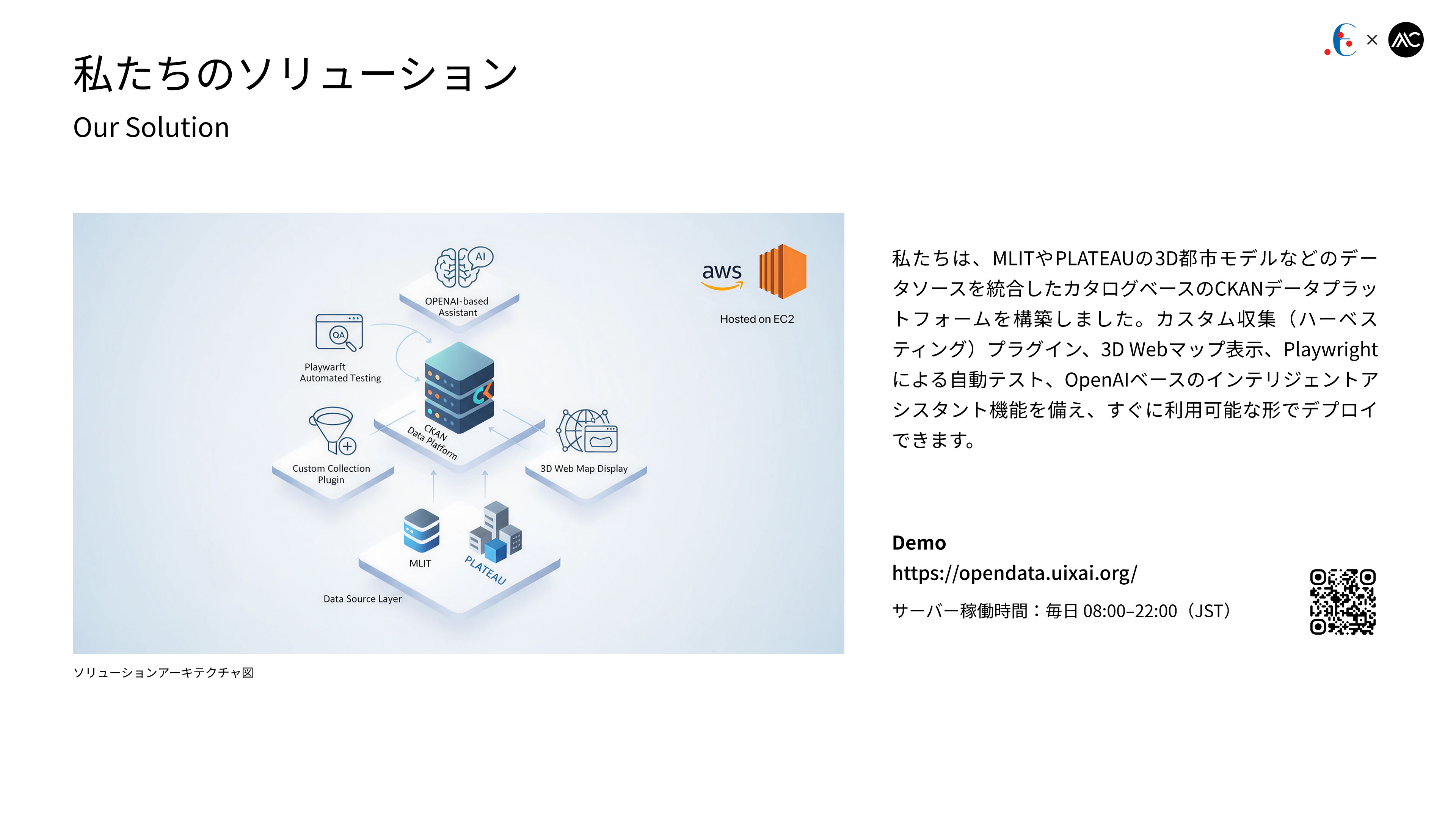
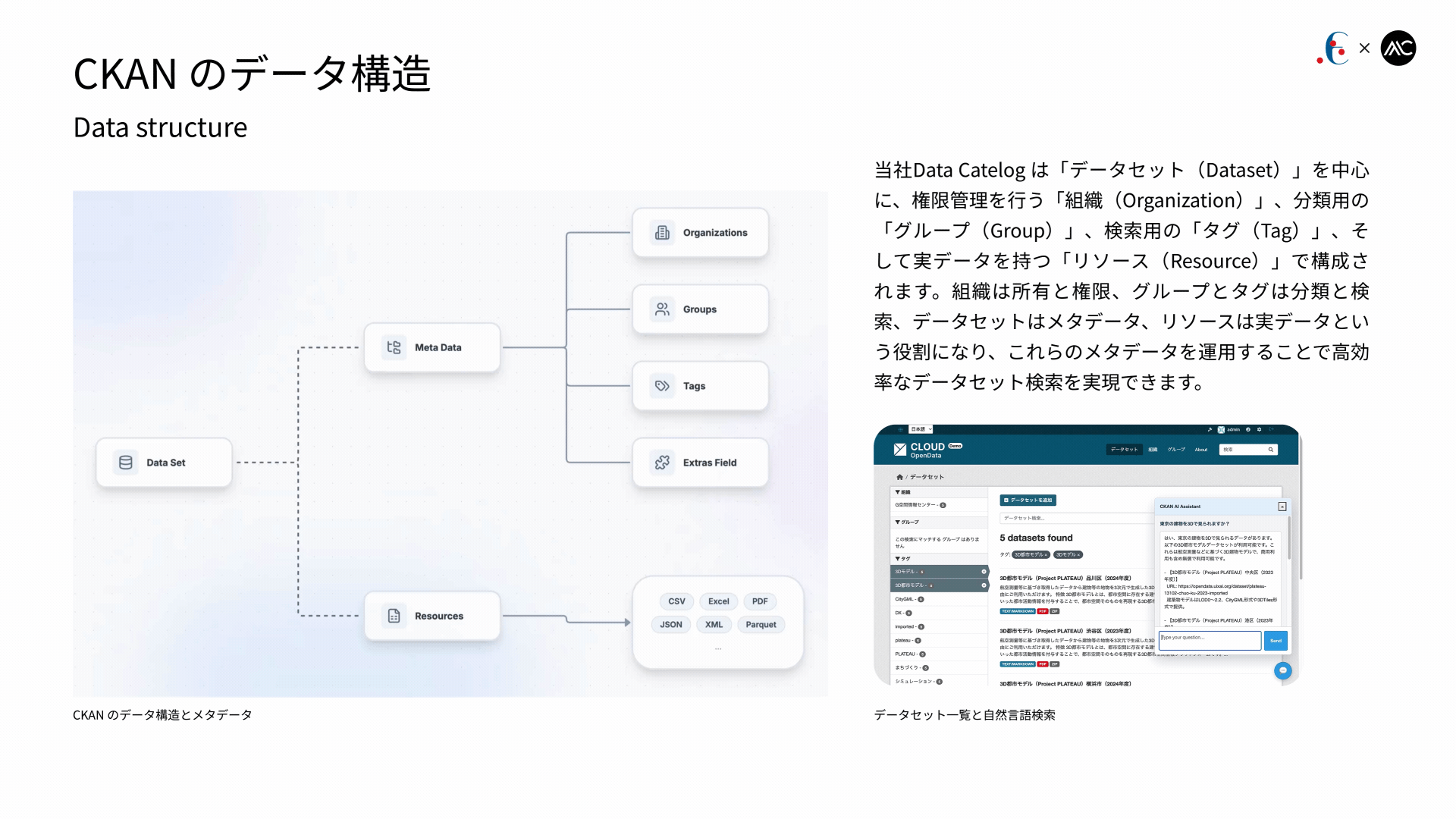
We have built a catalog-based CKAN data platform that integrates data sources such as MLIT and PLATEAU’s 3D urban models. It includes custom harvesting plugins, 3D web map visualization, Playwright-based automated testing, and an OpenAI-powered intelligent assistant, and can be deployed in a ready-to-use form.
私たちは、MLITやPLATEAUの3D都市モデルなどのデータソースを統合した、カタログベースのCKANデータプラットフォームを構築しました。カスタム収集(ハーベスティング)プラグイン、3D Webマップ表示、Playwrightによる自動テスト、OpenAIベースのインテリジェントアシスタント機能を備え、すぐに利用可能な形でデプロイできます。
私たちは、MLITやPLATEAUの3D都市モデルなどのデータソースを統合した、カタログベースのCKANデータプラットフォームを構築しました。カスタム収集(ハーベスティング)プラグイン、3D Webマップ表示、Playwrightによる自動テスト、OpenAIベースのインテリジェントアシスタント機能を備え、すぐに利用可能な形でデプロイできます。
We have built a catalog-based CKAN data platform that integrates data sources such as MLIT and PLATEAU’s 3D urban models. It includes custom harvesting plugins, 3D web map visualization, Playwright-based automated testing, and an OpenAI-powered intelligent assistant, and can be deployed in a ready-to-use form.
私たちは、MLITやPLATEAUの3D都市モデルなどのデータソースを統合した、カタログベースのCKANデータプラットフォームを構築しました。カスタムハーベスティングプラグイン、3D Webマップ表示、Playwrightによる自動テスト、OpenAIベースのインテリジェントアシスタント機能を備え、すぐに利用できる形でデプロイ可能です。
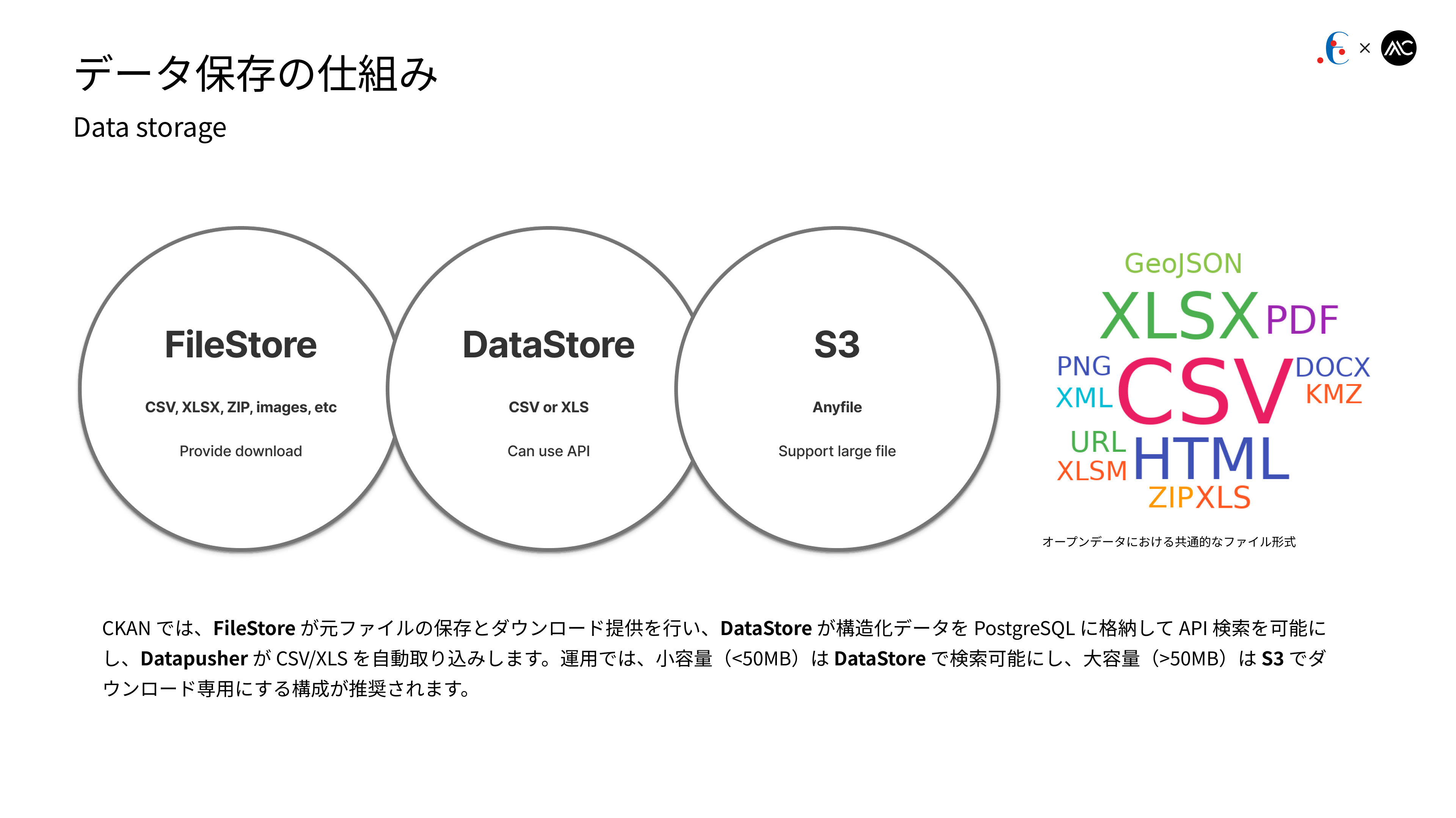
In CKAN, FileStore stores original files and provides downloads, DataStore loads structured data into PostgreSQL for API-based search, and Datapusher automatically ingests CSV/XLS files. In practice, a recommended setup is to store small files (<50 MB) in the DataStore for querying, and large files (>50 MB) in S3 for download-only.
CKANでは、FileStoreが元ファイルの保存とダウンロード提供を行い、DataStoreが構造化データをPostgreSQLに格納してAPI検索を可能にし、DatapusherがCSV/XLSを自動取り込みします。運用上は、小容量(<50MB)はDataStoreで検索可能にし、大容量(>50MB)はS3でダウンロード専用にする構成が推奨されます。
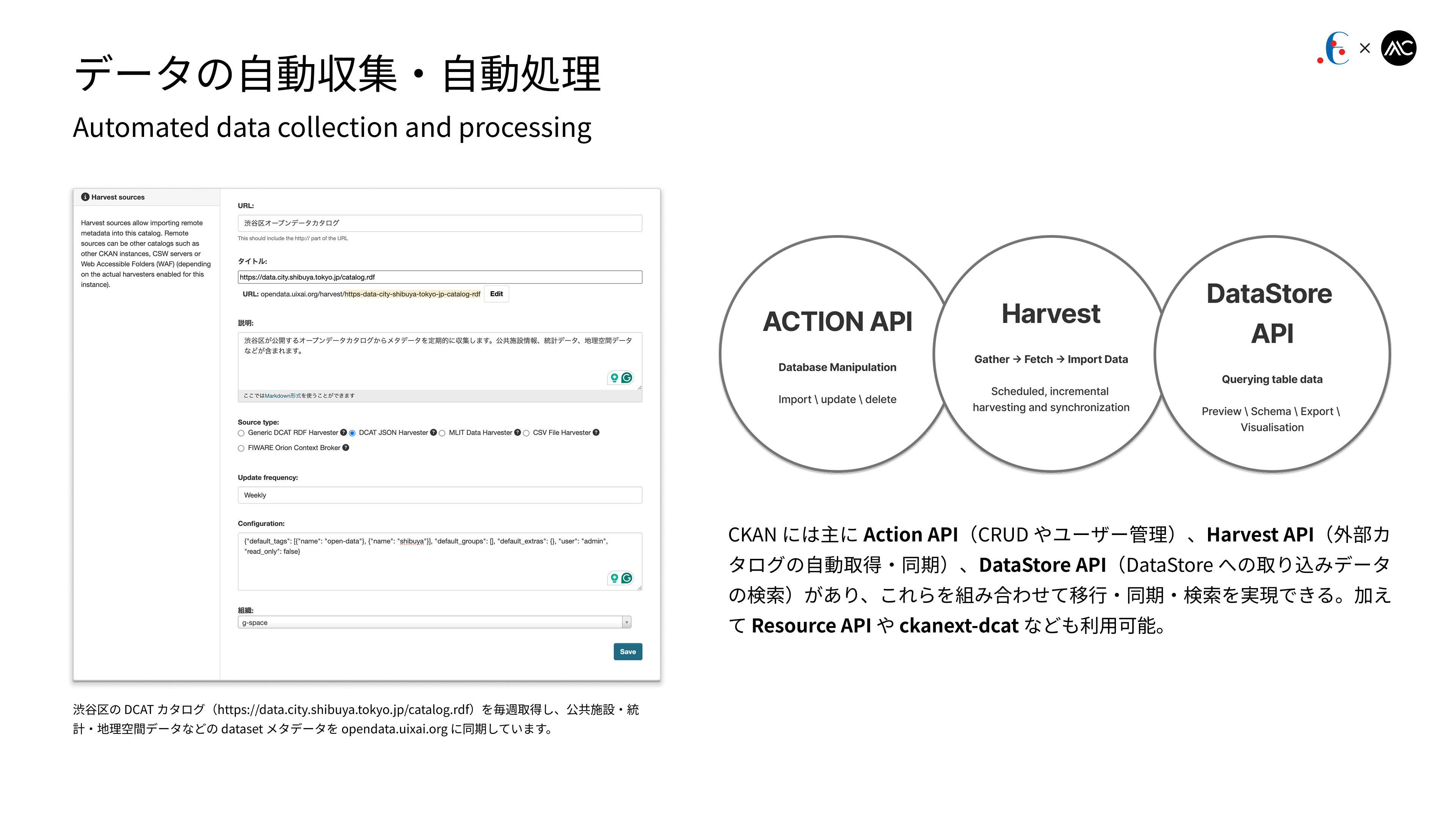
CKAN mainly provides the Action API (CRUD and user management), the Harvest API (automatic acquisition and synchronization of external catalogs), and the DataStore API (querying data ingested into the DataStore). By combining these, migration, synchronization, and search can be achieved. Additional interfaces such as the Resource API and ckanext-dcat are also available.
CKANには主に、Action API(CRUDやユーザー管理)、Harvest API(外部カタログの自動取得・同期)、DataStore API(DataStore取り込みデータの検索)があり、これらを組み合わせて移行・同期・検索を実現できる。また、Resource APIやckanext-dcatなども利用可能である。
CKANには主に、Action API(CRUDやユーザー管理)、Harvest API(外部カタログの自動取得・同期)、DataStore API(DataStore取り込みデータの検索)があり、これらを組み合わせて移行・同期・検索を実現できる。また、Resource APIやckanext-dcatなども利用可能である。
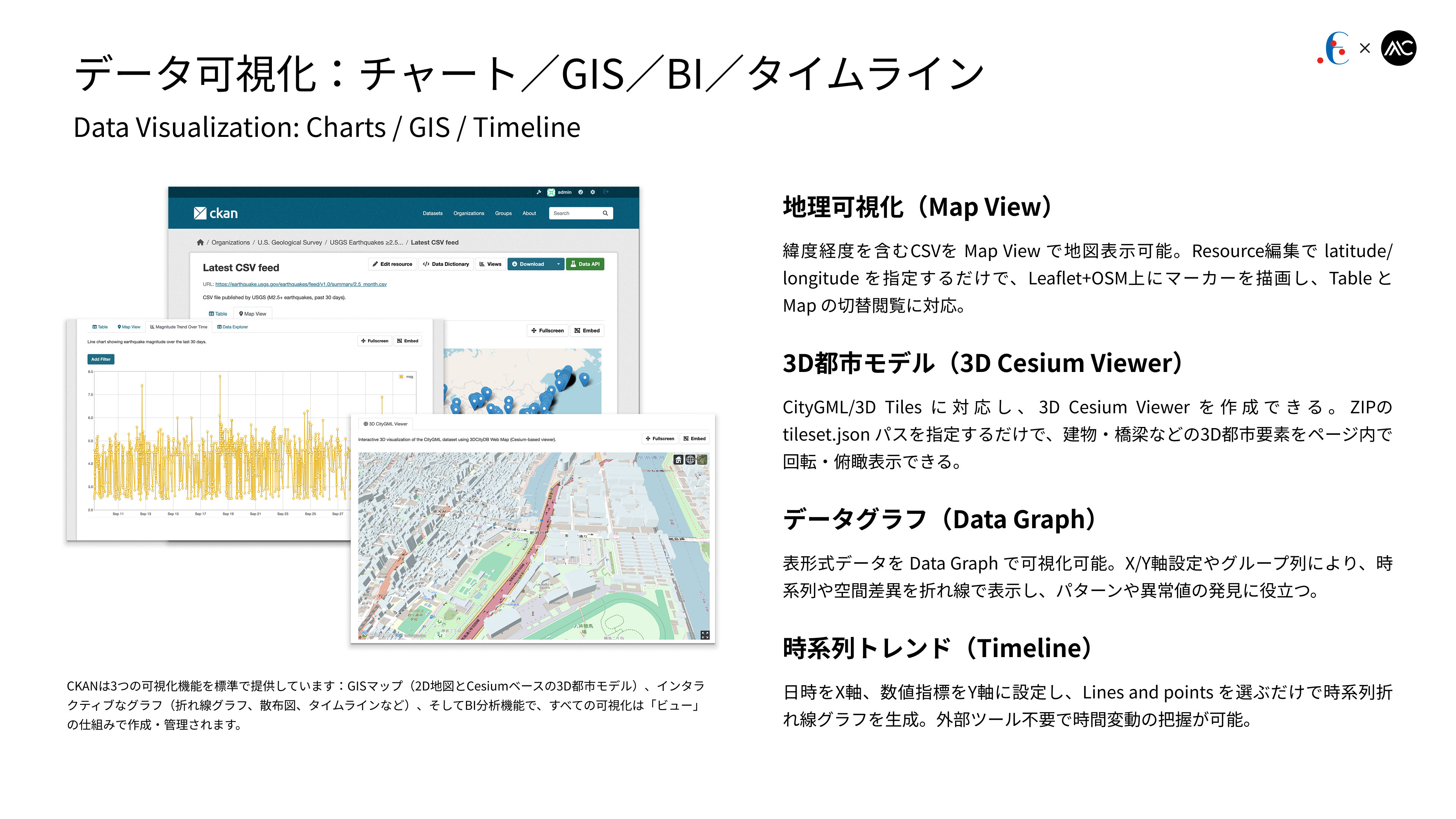
Our platform supports multiple visualization modes: Map View displays CSV data with latitude/longitude as markers on a map; the 3D Cesium Viewer renders CityGML/3D Tiles by specifying a tileset.json; Data Graph visualizes tabular data with configurable X/Y axes and grouping; and the Timeline view generates time-series line charts without the need for external tools.
本プラットフォームは複数の可視化に対応しており、Map Viewでは緯度経度付きCSVを地図上に表示し、3D Cesium Viewerではtileset.jsonを指定するだけでCityGML/3D Tilesを3D表示できます。Data Graphでは表形式データをX/Y軸設定やグループ別で可視化し、Timelineでは外部ツール不要で時系列折れ線グラフを生成できます。
本プラットフォームは複数の可視化に対応しており、Map Viewでは緯度経度付きCSVを地図上に表示し、3D Cesium Viewerではtileset.jsonを指定するだけでCityGML/3D Tilesを3D表示できます。Data Graphでは表形式データをX/Y軸設定やグループ別で可視化し、Timelineでは外部ツール不要で時系列折れ線グラフを生成できます。
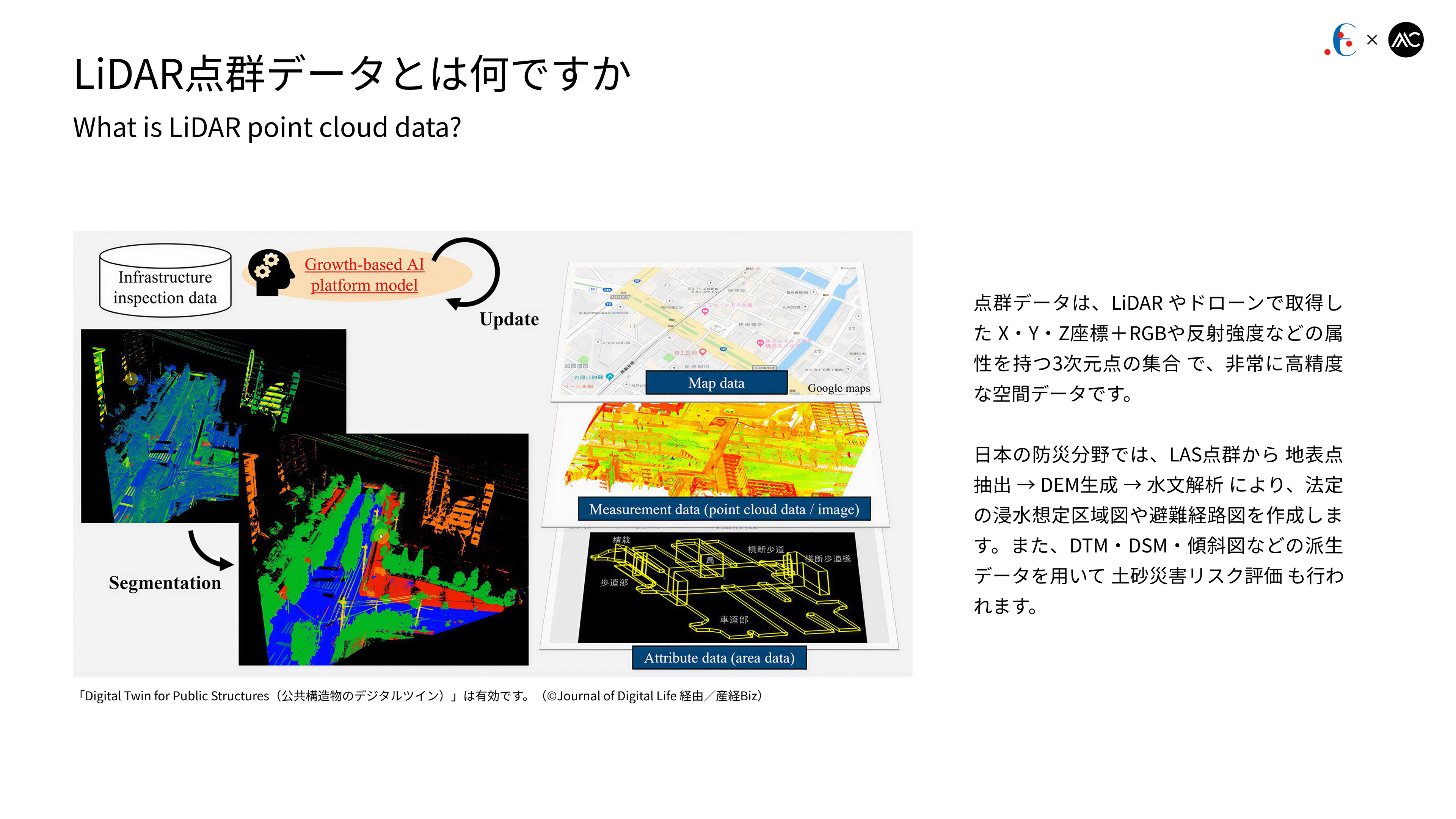
Point cloud data refers to highly accurate 3D spatial datasets captured by LiDAR or drones, consisting of X/Y/Z coordinates with attributes such as RGB and reflectance intensity. In Japan’s disaster prevention domain, surface points are extracted from LAS point clouds to generate DEMs and perform hydrological analysis for legally mandated inundation hazard and evacuation route maps, while derived datasets such as DTMs, DSMs, and slope maps are also used for landslide risk assessment.
点群データは、LiDARやドローンで取得したX・Y・Z座標とRGB・反射強度などの属性を持つ高精度な3次元空間データであり、日本の防災分野ではLAS点群から地表点抽出→DEM生成→水文解析により法定の浸水想定区域図や避難経路図を作成し、DTM・DSM・傾斜図などの派生データを用いて土砂災害リスク評価も行われます。
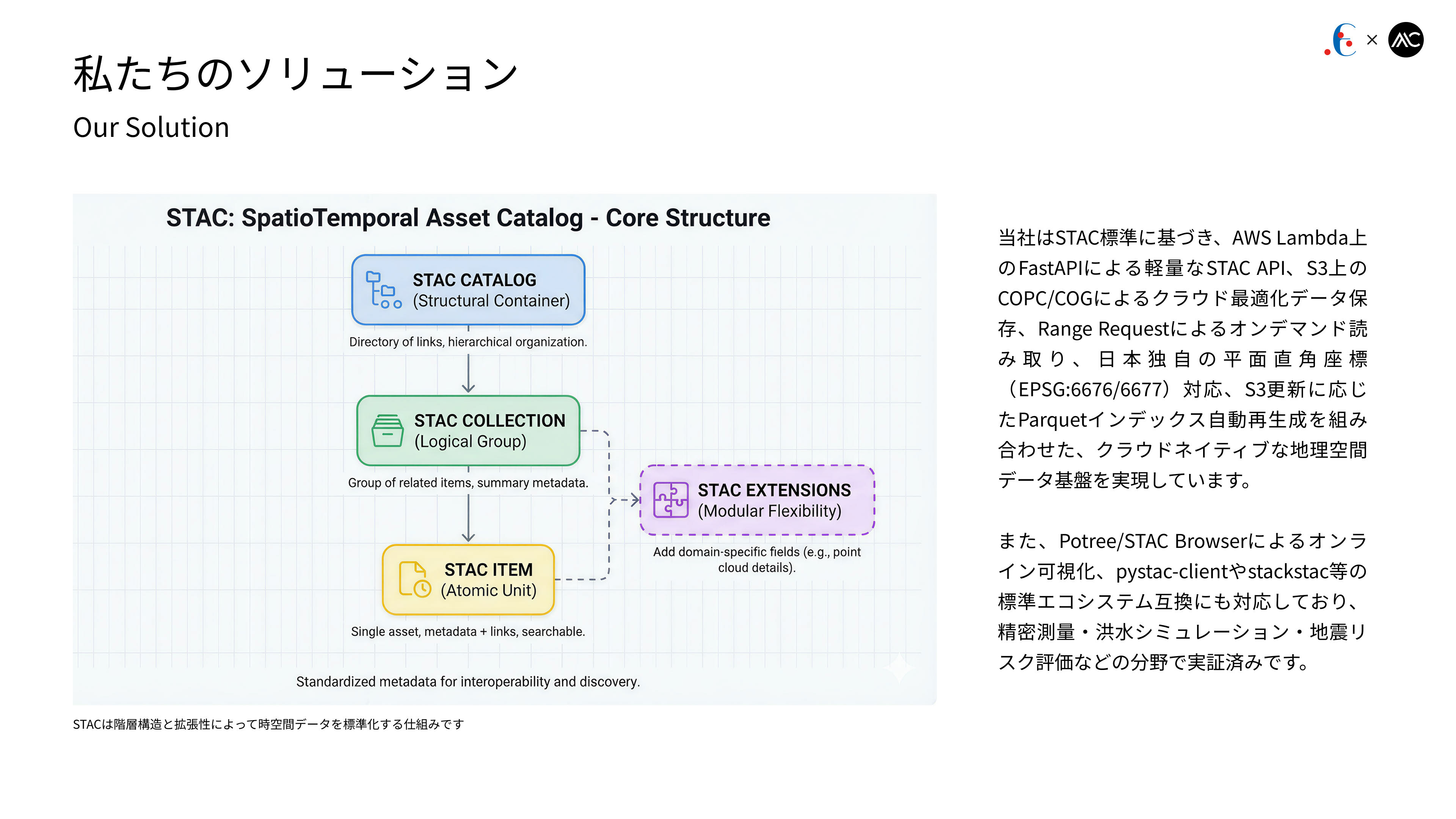
We provide a cloud-native geospatial platform based on the STAC standard, featuring a lightweight STAC API on AWS Lambda (FastAPI), COPC/COG storage on S3 with Range-Request on-demand access, EPSG:6676/6677 support, and automatic Parquet indexing from S3 updates. Online visualization (Potree / STAC Browser) and interoperability with pystac-client / stackstac are supported, with proven use cases in precision surveying, flood simulation, and seismic risk assessment.
当社はSTAC標準に基づくクラウドネイティブな地理空間基盤を提供しており、AWS Lambda上のFastAPIによるSTAC API、S3上のCOPC/COG保存とRange Request対応、EPSG:6676/6677対応、S3更新に応じたParquetインデックス自動再生成を備えています。さらにPotree/STAC Browserによる可視化とpystac-client/stackstacとの互換を実現し、精密測量・洪水シミュレーション・地震リスク評価などで実証されています。
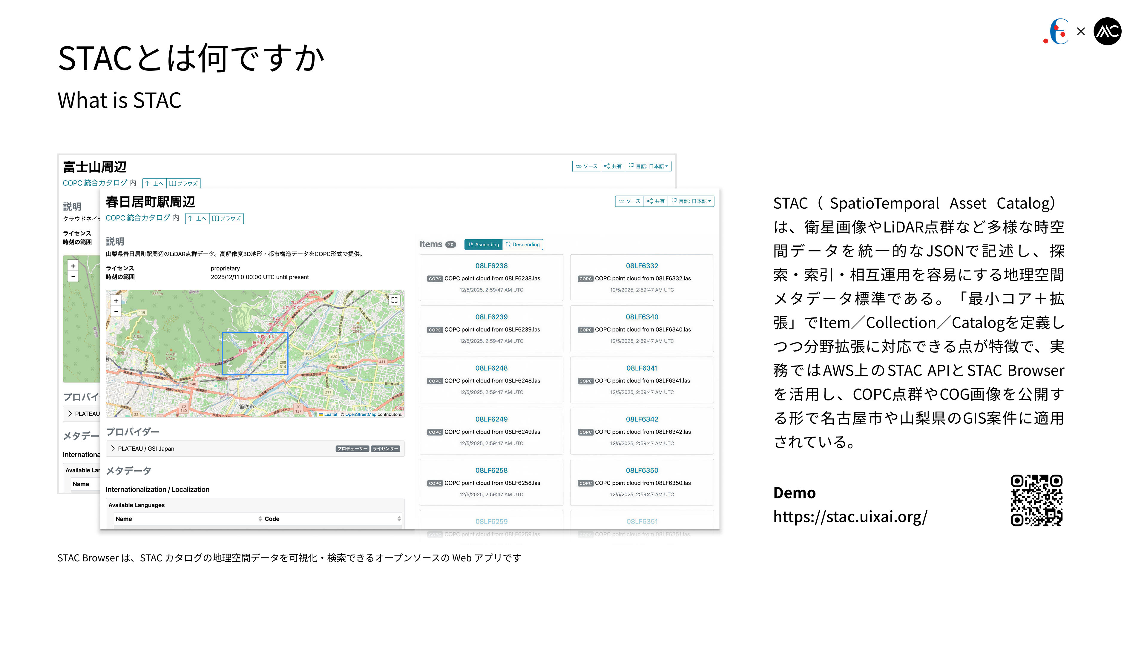
STAC (SpatioTemporal Asset Catalog) is a geospatial metadata standard that represents satellite imagery, LiDAR point clouds, and other spatiotemporal data in a unified JSON format for efficient search and interoperability. Using a “core + extensions” model for Items, Collections, and Catalogs, it is commonly deployed with STAC API and STAC Browser on AWS to publish COPC point clouds and COG imagery, and has been used in municipal GIS projects such as Nagoya and Yamanashi.
STAC(SpatioTemporal Asset Catalog)は、衛星画像やLiDAR点群などの時空間データを統一的なJSONで記述し、探索と相互運用を容易にする地理空間メタデータ標準である。「コア+拡張」でItem/Collection/Catalogを扱い、AWS上のSTAC APIとSTAC BrowserでCOPC点群やCOG画像を公開する形が一般的で、名古屋市や山梨県などのGIS案件でも利用されている。
Demo: https://stac.uixai.org/
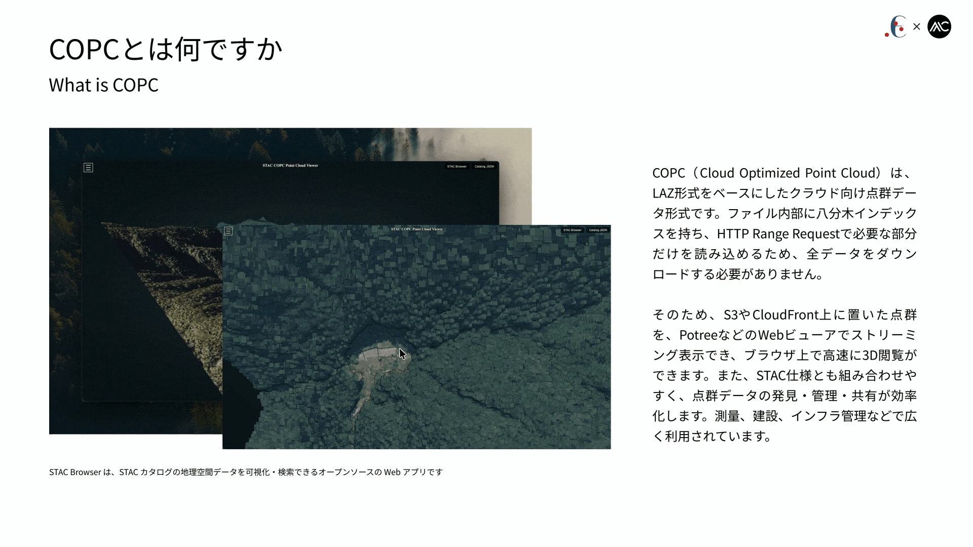
COPC (Cloud Optimized Point Cloud) is a cloud-friendly point-cloud format based on LAZ, featuring an internal octree index that allows partial reads via HTTP Range Requests without downloading entire files. This enables point clouds stored on S3 or CloudFront to be streamed into web viewers such as Potree for fast 3D visualization in the browser. COPC integrates well with STAC for efficient discovery, management, and sharing, and is widely used in surveying, construction, and infrastructure applications.
COPC(Cloud Optimized Point Cloud)はLAZを基にしたクラウド向け点群形式で、内部に八分木インデックスを持ち、HTTP Range Requestで必要部分のみを読み込めるため、全量ダウンロードが不要です。S3やCloudFront上の点群をPotreeなどへストリーミング表示でき、ブラウザで高速な3D閲覧が可能です。またSTAC仕様とも組み合わせやすく、点群の発見・管理・共有を効率化し、測量・建設・インフラ分野で利用されています。
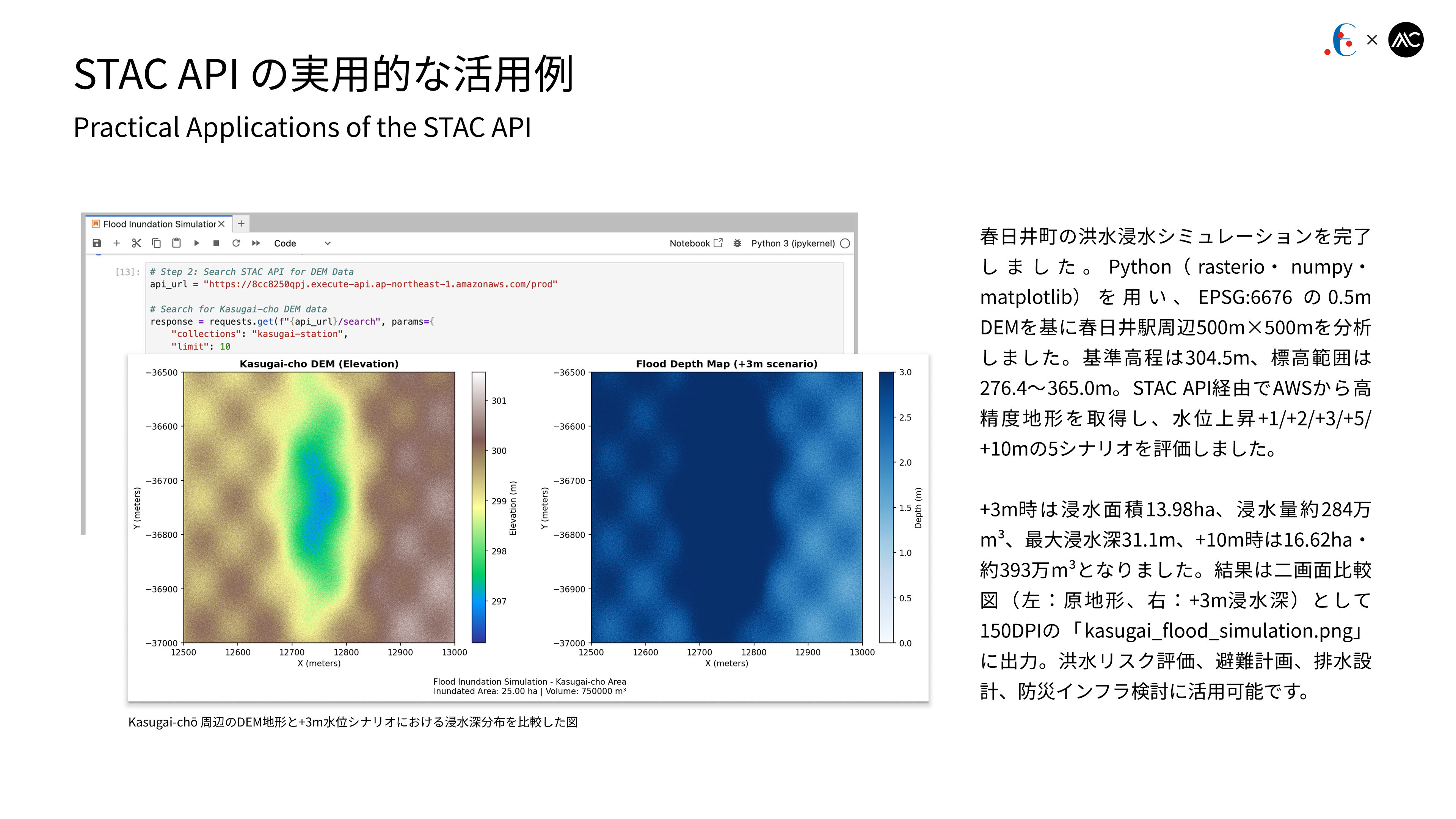
We ran a flood simulation for the Kasugai area using Python (rasterio/numpy). A 0.5 m DEM (EPSG:6676) around Kasugai Station (500×500 m) was processed via STAC API on AWS under five water-level scenarios (+1/+2/+3/+5/+10 m). The +3 m case yielded 13.98 ha of inundation (≈2.84 Mm³) and the +10 m case 16.62 ha (≈3.93 Mm³). Results were saved as a dual-panel image (“kasugai_flood_simulation.png”) for flood-risk and planning use.
春日井町の洪水シミュレーションをPython(rasterio/numpy)で実施しました。春日井駅周辺500×500 mの0.5 m DEM(EPSG:6676)をSTAC API経由で取得し、+1/+2/+3/+5/+10 mの5シナリオを評価。+3 mで13.98 ha(約284万m³)、+10 mで16.62 ha(約393万m³)となり、結果は二画面画像「kasugai_flood_simulation.png」として出力しました。
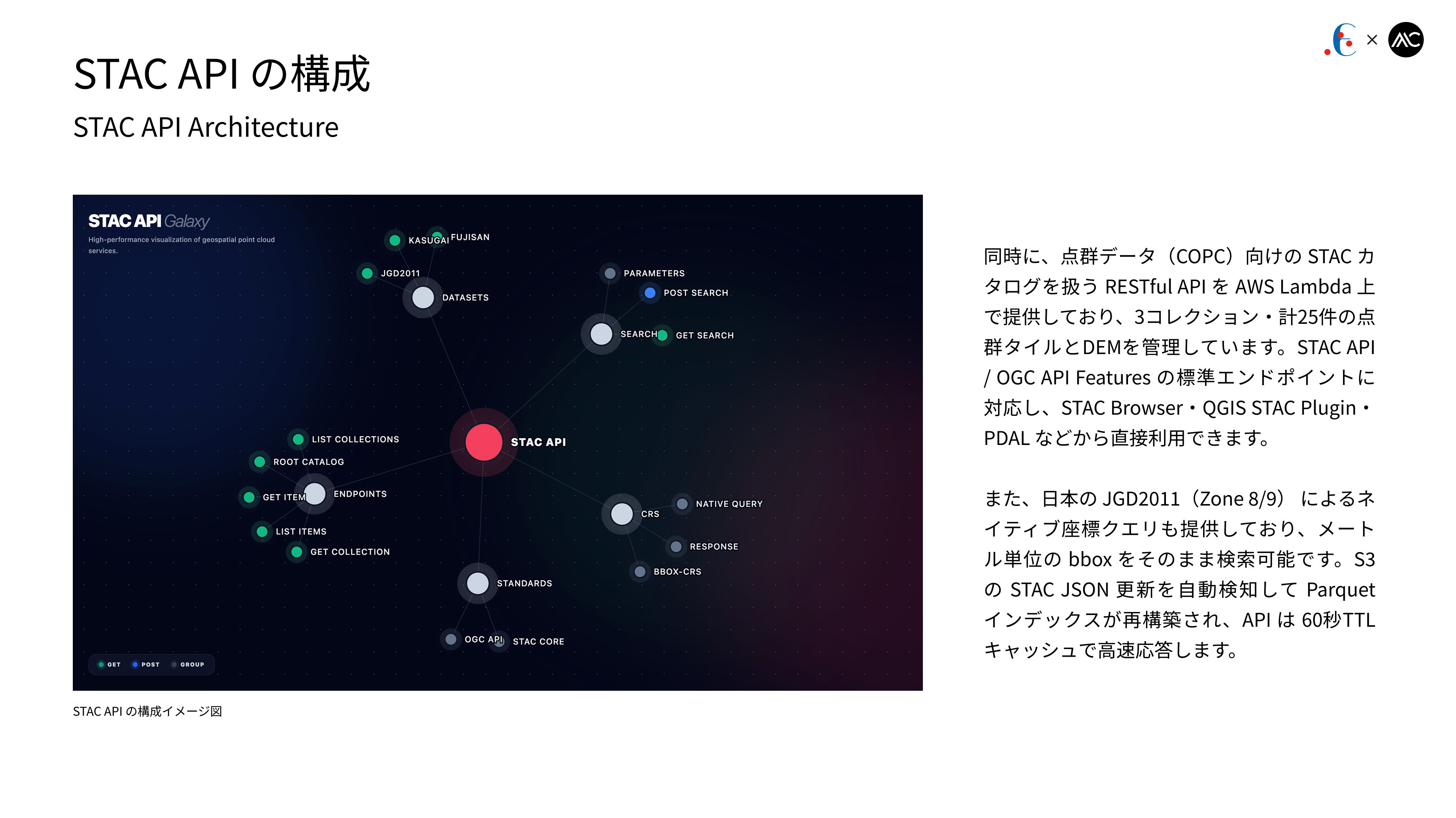
We also provide a RESTful API on AWS Lambda for managing STAC catalogs of COPC point clouds, currently hosting three collections with 25 point-cloud tiles and DEM layers. It supports standard STAC API / OGC API Features endpoints and can be accessed directly from STAC Browser, QGIS STAC Plugin, and PDAL. Native JGD2011 (Zone 8/9) metric bbox queries are supported, and S3 STAC JSON updates automatically trigger Parquet re-indexing with a 60-second TTL cache for fast responses.
同時に、COPC向けSTACカタログを扱うRESTful APIをAWS Lambda上で提供しており、3コレクション・計25件の点群タイルとDEMを管理しています。STAC API / OGC API Features標準に対応し、STAC Browser・QGIS STAC Plugin・PDALから直接利用可能です。またJGD2011(Zone 8/9)のメートル単位bbox検索に対応し、S3のSTAC JSON更新を自動検知してParquetインデックスを再構築、APIは60秒TTLキャッシュで高速応答します。
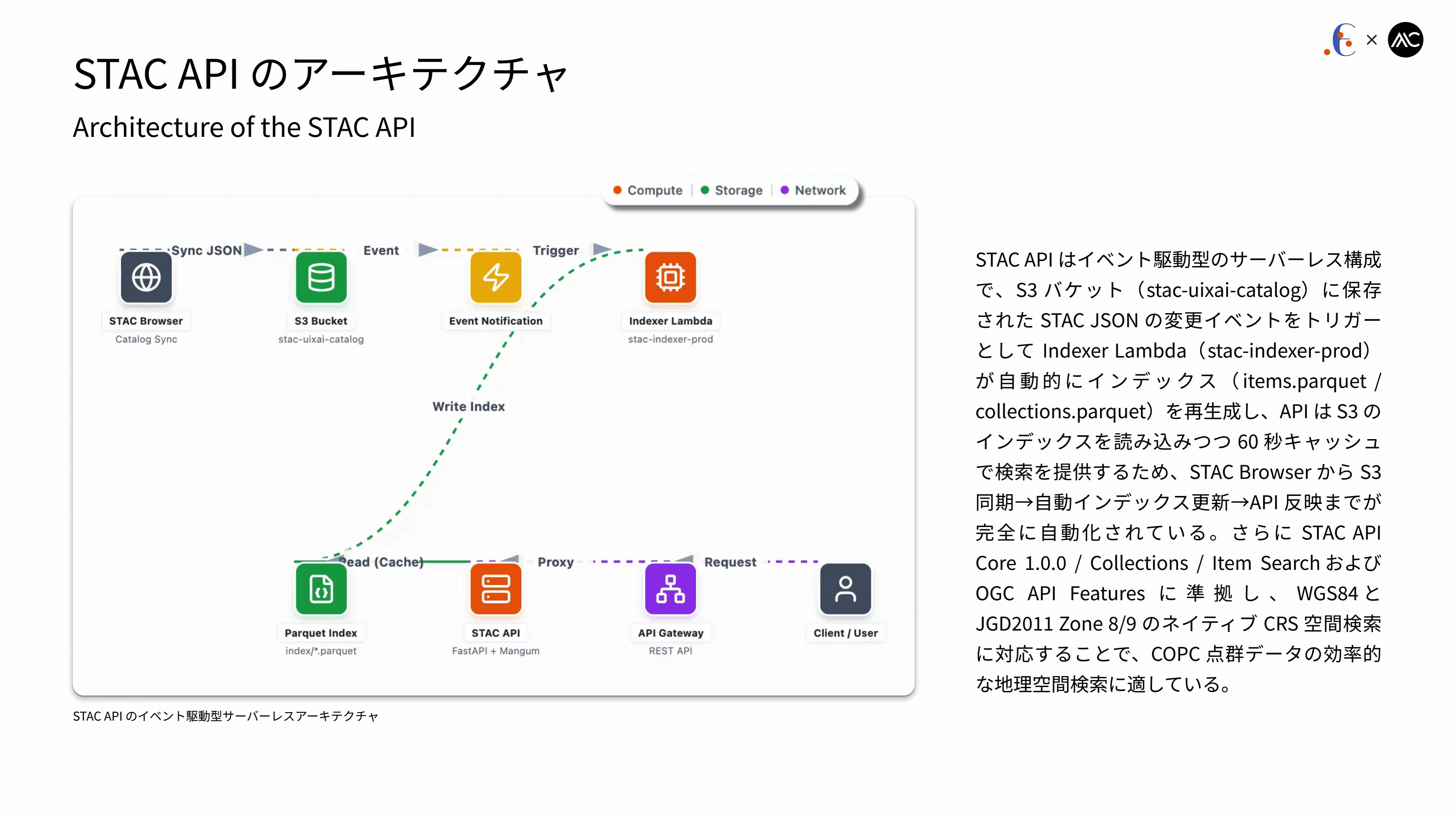
The STAC API is implemented as an event-driven, serverless architecture in which S3 updates to STAC JSON trigger an Indexer Lambda that automatically regenerates Parquet indexes (items / collections). The API reads these indexes from S3 and serves searches with a 60-second cache, enabling a fully automated workflow from STAC Browser sync to API reflection. It conforms to STAC API Core 1.0.0 / Collections / Item Search and OGC API Features, and supports native spatial queries in WGS84 and JGD2011 Zone 8/9 for efficient COPC point-cloud search.
STAC APIはイベント駆動のサーバーレス構成で、S3上のSTAC JSON更新をトリガーにIndexer LambdaがParquetインデックス(items / collections)を自動再生成し、APIはS3インデックスを読み込みつつ60秒キャッシュで検索を提供します。STAC Browser同期→インデックス更新→API反映まで自動化されており、STAC API Core 1.0.0 / Collections / Item SearchおよびOGC API Featuresに準拠、さらにWGS84とJGD2011 Zone 8/9のネイティブ空間検索に対応してCOPC点群の効率的な検索が可能です。